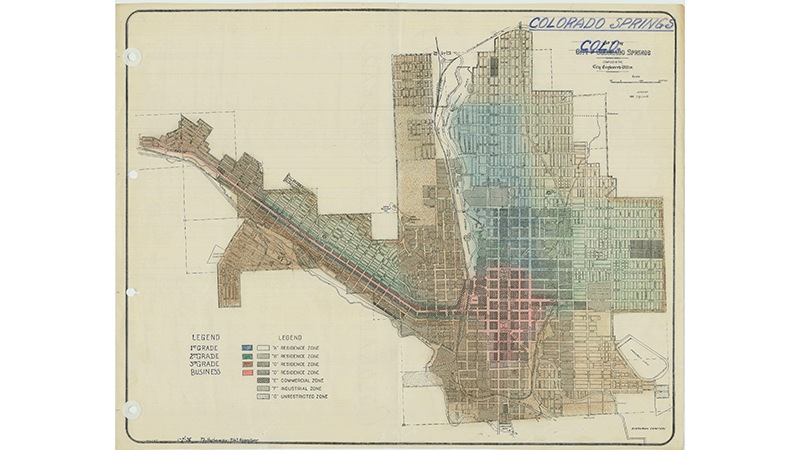
A draft map commissioned in 1936 by the federally sponsored Home Owners Loan Corporation shows Colorado Springs was not immune to redlining. U.S. National Archives and Records Administration
A draft map commissioned in 1936 by the federally sponsored Home Owners Loan Corporation shows Colorado Springs was not immune to redlining. U.S. National Archives and Records Administration
(Editor’s note: This is a longer version of an op-ed that was published in The Gazette newspaper in Colorado Springs on Nov. 11, 2018.)
A draft of PlanCOS, the first comprehensive plan for Colorado Springs in more than 15 years, debuted in the summer. Comprehensive plans are used across the country to guide decision making about future development. PlanCOS sets out a vision of Colorado Springs that is centered around diverse and safe neighborhoods, a thriving economy and a strong sense of the city’s historical legacy.
All of these are worthwhile goals, and this plan couldn’t come at a more opportune time. In a period of remarkable growth and development in Colorado Springs, it’s important to be deliberate in how we imagine the future of our city, and how we as citizens carry out this vision.
Rapid growth and change can also come with heavy burdens. Too many of our fellow Colorado Springs residents have been priced out of their neighborhoods, or are struggling with changing landscapes that feel disorienting, or where they suddenly feel out of place. It’s important that these burdens don’t fall too heavily on any one community.
The PlanCOS steering committee estimates that the final plan will be accepted and approved by City Council in December. Given that PlanCOS will guide our city’s decisions about how to allocate resources and preserve the history embedded in our homes, streets and institutions, it is worth considering the lessons of another time of monumental change in our city.
In the wake of the Great Depression, the federal government created a fund of about $3 billion to refinance underwater mortgages. Several years later, a federally sponsored entity called the Home Owners Loan Corporation (HOLC) set out to determine the risks of the government’s ongoing investments in the housing market. The HOLC tapped local appraisers—including lenders and real estate agents—to create maps of cities across the country showing investment risk, delineated by neighborhoods graded A through D.
Their instructions to these local appraisers were explicit. They were to assess the quality of the housing and the institutions in the neighborhood—and they were also to make assessments on the quality of the people living there, based on their race and ethnicity.
The resulting classifications were shamelessly racist. In Pueblo, appraisers gave this justification for a neighborhood they graded D, according to documents obtained from the U.S. National Archives:
“This area contains the heaviest concentration of negroes of any in the city. The ‘colored belt’ is chiefly that lying between Sixth Street and Ninth Street and Grand Avenue and West Street. It is a semi-industrial section wherein the houses are old and ill-kept. An inferior class of white people, many of them foreigners, chiefly Mexicans, also occupy this section.”
The presence of a single African-American person—with an exception made for domestic servants—was enough for a whole neighborhood to be given a D grade, and shaded red. This process was known as redlining.
The resulting maps depressed home values in C- and D-graded neighborhoods for decades to come by systematically robbing them of investment, punishing people of color as well as their white neighbors.
Scholars debate whether these redlining maps caused segregation and concentrated poverty, or merely reflected the discriminatory systems already at play. What is clear, however, is that by and large, historically redlined neighborhoods are today poorer and unhealthier than neighborhoods that were given higher grades for overtly racist reasons 80 years ago.
A redlined map of Colorado Springs was never published. But that doesn’t mean that the city was free from the effects of redlining.
My colleague Kristin Jones’s recent request to the National Archives found that in 1936, the HOLC did commission local lenders to create a “residential security map” of Colorado Springs. The justification for the appraisers’ decisions are lost to history, but the resulting draft map still exists.
Local appraisers marked in blue the residential neighborhoods that they deemed most worthy of investment—including the neighborhoods we now call the Old North End and Monument Valley. In the middle were neighborhoods like Middle Shooks Run, Divine Redeemer and Old Colorado City.
They shaded in brown the neighborhoods they assessed as risky—including Hillside, Mill Street, and the Conejos district, a historically working-class neighborhood that later dwindled and was eventually razed by the city to make room for America the Beautiful Park.
LaDale Winling is a Virginia Tech University history professor who worked on collecting redlining maps for the Mapping Inequality project. He told Jones that by the act of commissioning these maps and giving explicit instructions on how to view “negro” and “Mexican” neighbors, the HOLC was giving appraisers—including local business owners and lenders—an education in discriminatory lending. The process itself—a kind of early crowd-sourcing effort—established the federal priorities for investment, and guided local business owners to view neighborhood boundaries in terms of race.
As we plan for the future of Colorado Springs, it is important to make sure we are not reinforcing old patterns. The first step is to recognize the legacy of racism in our modern map of the city.
Today, the Old North End, a neighborhood singled out as “good” by the draft HOLC map, has high home values and low rates of poverty; its residents are mostly white.
Mill Street and Hillside—which certainly would have been flagged by those 1930s-era appraisers as being home to non-white residents and, therefore, “risky”—have struggled against official and informal neglect, and a persistent lack of investment in the community.
Residents’ interests have been repeatedly bulldozed, sometimes literally. Homes in Mill Street were razed to make room for the Martin Drake coal-fired power plant, now slated to be decommissioned. In Hillside, the community center and a church are squeezed between a wastewater treatment plant, salvage yards and a concrete supplier. Taxpayer dollars were spent extracting value from the land for the benefit of industry, not the benefit of the people living here.
None of this is the fault of today’s city planners. But without being aware of this history, our city risks repeating it. Like the draft redlining map of the 1930s, PlanCOS’s draft neighborhoods framework shades the Old North End in blue. Along with Old Colorado City, parts of the Westside and Old Broadmoor, it is envisioned as an “established historic neighborhood.” PlanCOS gives these neighorhoods “an especially high value for preserving the existing design and architecture,” though it goes on to say that even these neighborhoods should expect to experience some change.
Other neighborhoods, though just as historic, don’t get the same designation. But why don’t Hillside and Mill Street—once disregarded by local appraisers who were coached by the federal government to make racist distinctions—merit the same level of protection from the burdens of rapid change and heavy development?
Both Mill Street and Hillside are experiencing a spate of public and private investment intended to revitalize downtown Colorado Springs. There are plans for a new stadium in the Mill Street neighborhood, and both neighborhoods have seen new investment supporting parks, bike and trail infrastructure. None of these are bad in themselves. But they have the potential to drive up housing costs, and to drive out or marginalize current residents. As in the past, the direct beneficiaries of this development are not necessarily the people living in the community.
Colorado Springs has an opportunity to create a plan that benefits the people living here, and our shared history. PlanCOS has the potential to assure that the benefits and burdens of growth are equitably distributed across our city, and to help to repair the damage done in the past.
We can build a more inclusive city through public investments and public-private partnerships that are aimed at building wealth in areas of persistent poverty. Community-wide commitment is needed to address areas of concentrated disadvantage, so that we don’t reinforce historic patterns of segregation and division.
Today, the growth of Colorado Springs offers opportunities for a thriving economy, and for integrated and healthy neighborhoods. It is worth preserving the historical legacies that make us proud. Let’s just make sure that we don’t enshrine the histories that don’t.
Let PlanCOS reflect a city that values equity and inclusion, acknowledges its history and learns from the past.